Welcome to the communes of Trinité, located to the east of the island of Martinique on the edge of the Atlantic Ocean.
The town of Trinité is known for its beaches and its surf spot (Tartane), its fish market and its Hardy distillery, created in 1830 and bought by Gaston Hardy in 1905.
Within the town, you will also find in terms of services a covered market, banks, gas station and post office.
There are also many hikes to do in this area, including one of the best known in Martinique, the magnificent Caravelle Peninsula hike or the Anse Spoutourne – Morne Pavillon hike that I am showing you today.
Itinerary (Click on the picture)
To reach the starting point of the hike, leaving from Fort-de-France, join the A1 expressway then exit towards the commune of Robert (N1). From this exit, allow a 45-minute drive, follow the direction of the communes of Robert, Trinité then Tartane. On the road to Tartane (Château Dubuc, D2) after about ten minutes, you will see on your right a sign towards Anse Spoutourne and its nautical base. Park in the nautical base car park, you are at the starting point of the hike.


The start of the hike is at the end of the parking lot. Take the path to Anse Spoutourne.

The Loop of Anse Spoutourne – Morne Pavillon

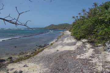
The Anse Spoutourne – Morne Pavillon hike takes you to discover the Atlantic side coastline of the commune of Trinité, south of Tartane. Magnificent panoramas will follow one another as you progress along the coast. A discovery of the beaches, the mangroves and the slopes of Morne Pavillon on this side of the island. The trail is accessible to the whole family (children over 8 years old and depending on physical condition) and covers 10 kilometers (loop) with a walking time of 4.5 to 5.5 hours. You will have a positive altitude difference on the way out of around 200 m with a large climb to climb at Morne Pavillon in order to reach the return road.
Tip: You will have to demonstrate orientation and observation on certain passages in the mangrove to find the rest of the route (color point).
Take the Chemin de l’Anse Spoutourne to find yourself after a few minutes in front of a first sign.


The path crosses fields of livestock and crops and brings you to a beautiful house, Habitation Blin.


At the end of the path turn left to walk alongside the house then turn right to find the start of the track towards the first cove in Baie du Galion.


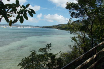
The route becomes shaded and more pleasant. Watch out for roots and mud in places to avoid falls. After a few minutes, a fork on your right, I invite you to take it to discover a little treasure of panorama in the Baie du Galion. You also access a small cove full of charm.


Once you have taken the time to contemplate this little treasure, retrace your steps and take the forest path again.

Posts are set up along the route.

First obstacle at the start of the loop, a ravine. For those who are better equipped you can cross this fairly muddy passage. Otherwise, you can take a short off-piste detour upstream to cross without setting foot in the water.
Another suggestion is that it may be possible to avoid this passage through the cove by going by sea.

Following the passage, the scenery changes slightly to give way to the mangrove and a magnificent view point on a hill.


More rocky, at the top of the hill, you can enjoy a last panorama before reaching Baie Gros Raisin.
Click on this link to have a first video preview of the panorama on our Facebook page.

The route then goes back down and you find yourself overlooking a beach.


Take the back beach path to reach Gros Raisin Bay and its magnificent white sand cove.


Click on this link to have a first video preview of the panorama on our Facebook page.

Gros Raisin Bay has the advantage of having been set up for possible bivouacs. However, like any good person who respects nature, don’t forget your waste and don’t leave your trash on site.


Continue your path to arrive along Grandjean Bay, corresponding to half of the hike.


This section will test your sense of observation (red and blue dots) and orientation. Spots of color should be spotted as well as paths should be favored in a constantly evolving eco-system. Generally very humid, be careful of slipping in this area.


With the mangrove behind you, you will walk along the bay. Unfortunately, a sad spectacle awaits you, a lot of plastic waste litters the ground on this part of the hike. At the bottom of the beach, the remains of a lime kiln indicate that Morne Pavillon is in your sights.


Here you are before the biggest obstacle of the loop. You will climb the slope of Morne Pavillon to Chemin en Bois.


The slope is steep and the heat is there in this unshaded area.

Arriving at the top of the slope, you join the Chemin en Bois road.


At the end of this path turn left, the slope is still steep and the sun is still out. Take the time to hydrate yourself, there is no point in running.

End of the climb and a small reward is present. A slight panorama of the Atlantic coast.

Continue the loop on this road, little traffic, however take your precautions.

At the end of this road, turn left. You recognize the road going towards the Spoutourne Nautical Base.


Another ten minutes and you arrive at the nautical base and its parking lot, marking the end of the loop.

It’s up to you to discover it now!
Miscellaneous
At the Water Activities Base, you can rent boats for, for example, towed tubing or wakesurfing in the bay.


More anecdotal and for tennis lovers, you also have private tennis lessons at this nautical base.

In terms of advice,
Ø Traffic in Martinique: During the week, you will face traffic jams around industrial or commercial areas, particularly in the morning, in the direction of the South (Rivières Salée, N5) towards the North (Fort-de-France, A1) and from the East (Robert, N1) to the North (Fort-de-France, A1), from 7 a.m. to 9:30 a.m., and vice versa at the end of the evening from 5:00 p.m. to 6:30 p.m. Think about your journey the day before in order to adapt to this traffic which can be heavy and easily cause you to waste time.
Ø Equipment: Good pair of grippy sneakers or hiking shoes, hiking pole, sports outfit, hiking bag (knife, flashlight, headlamp, k-way, cap, sunglasses, sunscreen).
Ø Health:
– Difficulty: 7 out of 10, paced walk with slight positive elevation changes and a large steep slope at Morne Pavillon, possible with a baby carrier or with children over 8 years old (depending on physical condition). The heat can make this hike quite sporty.
– In normal times, always start hiking as early as possible, the heat during the day during minimal sporting activity can become quite stifling.
– Go at your own pace and plan the time it will take depending on your physical condition.
– The most important thing, always a bottle of water per person and something to snack on in your bag. With the heat, any fairly physical hikes can be dangerous with fatigue.
Miscellaneous: you can enjoy the different beaches of the hike, notably that of Gros Raisin Bay. You can also take advantage of your presence not far from the town of Tartane to visit the Château Dubuc, discover the Baie du Trésor and its mangrove or swim in the waters on the beach of Pointe de la Brèche. Other areas of exploration exist even further north in the town of Sainte-Marie, see our site.
Do not hesitate to post you commentaries or to ask for information on contact@domloisirsetculture.fr.
Subscribe on our page on Facebook, where you will discover a new article or video every week.
Dom Loisirs et Culture at your service.
OLIVIER Damien, your humble guide


0 Comments